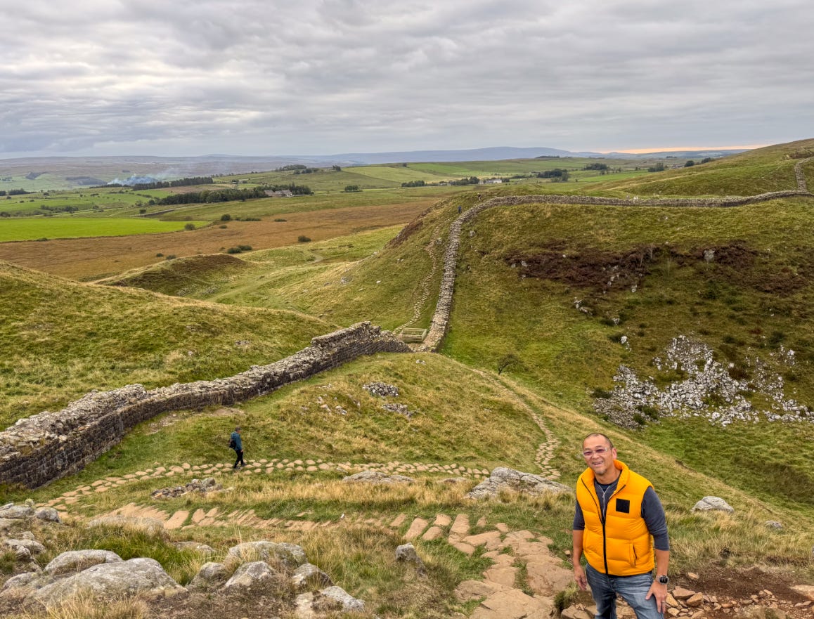
Travelog: Ruin Hunting (Roman Britannia & Hadrian's Wall)
I came to the Roman Empire’s northern frontier looking for ruins but found vestiges of an empire that were much more personal. This is my Travelog of what Rome built, lost, and left behind in Britain.
This fall, I traveled for four weeks, bookended by a Socratic seminar at Oxford in mid-September and an adventure retreat in Iceland in mid-October. I decided to fill up the two weeks in between with an in-depth exploration of Roman Britannia followed by an in-depth exploration of Northumberland and Scotland.
This Travelog focuses on the Roman Britannia segment, given my passion for Greco-Roman antiquity. My last two Travelogs were about monumental ruins scattered throughout Greece, Turkey, Sicily, and Tunisia:
Roman Britannia is totally different from anything else I’ve seen, and I came away from this trip with a profound appreciation for the difficulties facing a hegemon that overextended its borders. There are always modern lessons that can be drawn from studying ancient history.
Roman Britannia: Historical Context
Rome’s engagement with Britain began in 55–54 BCE, when Julius Caesar carried out two brief expeditions across the English Channel (more for reconnaissance than for conquest) to punish tribes who had aided his Gallic enemies. While Caesar made a beachhead, Rome did not return for nearly a century, until Claudius launched a full-scale invasion in 43 CE, using the conquest of Britain to legitimize his new reign. Within a generation, Rome controlled the southeast, built Londinium (modern London), and established the province of Roman Britannia.
Thirty-five years after the Claudian invasion, legionary bases had been established in Chester and in York for a move north into what is now Scotland. The indigenous tribes, initially friendly, ultimately became hostile to Roman rule, and the famous Roman general Gnaeus Julius Agricola was appointed governor of Britain in 78 CE to subdue the locals. Agricola won a major victory in 83 CE over the Caledonians at the Battle of Mons Graupius, but was not able to hold these gains as imperial priorities shifted elsewhere in the Empire.
During this period, many forts were established along a frontier known as the Stanegate, which was an east-west military road running from Corbridge (Coria) to Carlisle (Luguvalium) in what is now Northumberland and Cumbria in northern England.
Along it, Rome established a chain of forts, like famous Vindolanda, designed to support mobile field armies and rapid response rather than a continuous defensive line. This reflected an offensive, flexible frontier, with Rome still contemplating expansion into Caledonia (modern Scotland).
By the early 2nd century CE, however, imperial priorities had shifted and troops were withdrawn to bolster campaigns elsewhere. Rome under Trajan (ruling from 98 CE - 117 CE) reached its greatest geographical extent, as Trajan pushed an aggressive expansionist foreign policy in the eastern part of the Empire. The famous Column of Trajan in Rome celebrates Trajan’s conquest of Dacia, for example.
Reoccupying northern Britannia was no longer a priority for Rome, and archaeological evidence from forts in southern Scotland suggests that concerted military action by the northern tribes may have forced the Romans to abandon these forts by 105 CE and return to the Stanegate frontier.
When Trajan’s successor Hadrian (ruling from 117 CE - 138 CE) visited Britain in 122 CE, he abandoned the idea of further northern conquest and ordered the construction of a permanent frontier: Hadrian’s Wall. A serious threat from the north must have prompted Hadrian to reverse Trajan’s expansionist policy and focus instead on consolidation and containment of the Roman frontier.
Rather than starting from scratch, Roman engineers absorbed the Stanegate system into the new frontier, reusing its forts, supply routes, and logistical infrastructure. The Wall ran 73 miles (80 Roman miles) across northern England from Bowness-on-Solway in Cumbria to Wallsend in Northumberland at the mouth of the Tyne River.
Hadrian’s successor, Antoninus Pius, briefly pushed farther north into Caledonia in the 140s CE, building the Antonine Wall across the central belt of modern Scotland. Its occupation was short-lived, however, and Rome soon fell back to Hadrian’s Wall in the 160s CE.
In the early 3rd century, Septimius Severus shifted imperial attention back to Britain, launching massive campaigns into Caledonia and basing himself out of Eboracum (modern York), where he died in 211 CE; his presence underscores how strategically important Britain remained even during the empire’s later turbulence during the Crisis of the Third Century.
A century later, Eboracum again entered the imperial spotlight when Constantine the Great was proclaimed emperor there in 306 CE, a moment that would alter the trajectory of the Christian Roman world.
By the early 5th century, Rome was experiencing an echo of the Crisis of the Third Century, as the empire found itself overstretched again and beset by multiple external threats (Visigoths pressing into Italy, Vandals and Alans breaching the Rhine frontier), internal threats with imperial usurpers rising in rapid succession, and the treasury unable to sustain the enormous cost of frontier garrisons. Britannia, long a stable province, found itself increasingly marginalized as the empire prioritized defending the heartlands.
Imperial troops and administrators were gradually withdrawn, and when the Britons appealed to Rome in the early 5th century CE for military assistance, Emperor Honorius sent the famous “Rescript to the Britons,” essentially instructing the provincial communities to organize their own defense. Roman Britain did not collapse overnight, but imperial authority dissolved, leaving cities, forts, and communities to fend for themselves as new powers arrived in the power vacuum left by Rome.
When Rome withdrew around 410 CE, Britain entered a long twilight often labeled the “Dark Ages,” as written records grew scarce and power fractured into competing Brittonic kingdoms. Former Roman towns shrank or transformed, hillforts revived, and new groups like the Angles, Saxons, and Jutes arrived from across the North Sea, settling first along the eastern coast before pushing inland.
By the 6th century, these migrant societies were shaping early Anglo-Saxon England, while indigenous Brittonic groups like the Rheged, Strathclyde, and Gwynedd held the west and north. Christianity re-entered through both Irish and Roman missions, and over centuries the patchwork hardened into the early medieval kingdoms that would one day form England and Scotland. Modern England and Scotland were thus built in the long shadow of Roman Britannia.
Without further ado, follow my adventures from London to York and across the length of Hadrian’s Wall in Northumberland and Cumbria, as I sought to learn about what happened to a once vibrant Roman province that was left to fend for itself.
9/20/25 - 9/21/25 — London Museums
London
After Oxford, I spent two days in London just visiting museums to get in the mood for Roman Britannia.
Victoria & Albert Museum
If you’ve never been to the V&A in South Kensington, it’s a must.
I loved the sculpture galleries:
…but the Cast Courts were the highlight for me, because they have scale replicas of some of the most famous monuments in the world.
Here are two replica sections of the aforementioned Column of Trajan from Rome, which celebrates Trajan’s conquest of Dacia:
British Museum
I’ve been to the British many times, but I never get tired of this place, given its incredible collections of antiquity. Staying with the Roman theme of this Travelog, let’s meet some of the faces we’ll be hearing about.
Emperor Trajan (98-117 CE) expanded the Roman Empire to its greatest extent. The aforementioned Column of Trajan in Rome celebrated his conquest of the Dacians between 101-106 CE:
Emperor Hadrian (117-138 CE) succeeded Trajan and famously decided that the risk/reward of continuously expanding the Empire did not pay off. Instead, he focused on consolidation and defending its borders, which resulted in the construction of Hadrian’s Wall. Hadrian was also a Hellenophile and patron of arts and architecture and left his mark far and wide across the Empire, as detailed in my Roman Africa Travelog.
Emperor Antoninus Pius (138-161 CE) succeeded Hadrian and temporarily reversed his policy of consolidation, as he tried to push the Roman Britannia border further north into Caledonia. He built the Antonine Wall but could not hold it, and very little of it remains today.
9/22/25 — London → York (Eboracum)
York (Eboracum)
York, once known as Eboracum, was the capital of Roman northern Britain and one of the most important legionary bases in the entire empire. Modern York is a true juxtaposition of old and new:
York traces its history back to 71 CE, when the Roman 9th Legion arrived at the strategic spot where the Ouse and Foss Rivers. They built a fortress to defend themselves against the hostile locals, and this fortress housed up to 6000 legionnaires.
By the 4th century CE, there were massive stone walls which surrounded both the fortress and civilian town, and the Multangular Tower, part of the fortress defenses, survives to this day. Standing before the Multangular Tower, I could still see the distinctive Roman masonry at its base, stones laid by the Legio VI Victrix, which was one of the legions that built Hadrian’s Wall and later garrisoned here.
This is Micklegate Bar, the most important of York’s gateways. The present gateway was mostly built in the early 12th century, but there was been a gateway here since the Roman period:
We tried to go to the Yorkshire Museum, which houses a great Roman Britannia collection, but it had just changed to fall hours and was unfortunately closed the day we were in York:
York Minster
York Minster stands on the site of the Roman headquarters building (principia) of Eboracum, where imperial power was once exercised at the northern edge of the empire. It was here that Constantine the Great was proclaimed emperor in 306 CE, and the location remained a center of authority through the Anglo-Saxon period, when a wooden church rose over the Roman ruins.
Technically, a Cathedral is a church containing a bishop's throne (cathedra), making it the head church of a diocese, whereas a Minster is a historical term for a significant Anglo-Saxon church, often linked to missionary communities or monasteries.
York Minster, begun in 1220 CE and completed in 1472 CE, preserves that unbroken tradition of sacred and political importance stretching back to Rome and is the largest Gothic Minster/Cathedral in Northern Europe by interior floor area.
Sidebar: Constantine’s Crowning
Eboracum is famous for being the site where Constantine the Great was first proclaimed Roman Emperor. Outside York Minster is the statue that commemorates the crowning in 306 CE:
Constantine’s father, Constantius Chlorus, was one of the four rulers in Diocletian’s Tetrarchy, governing Britain and Gaul as Caesar and later Augustus. While campaigning in northern Britain against the Picts, Constantius fell ill and died at Eboracum on July 25, 306. Constantine was present with the army when this happened and was already familiar with the legions, who immediately proclaimed Constantine emperor.
His position was not immediately secure or universally recognized, however. The senior Augustus, Galerius, refused to accept the army’s acclamation and instead recognized Constantine only as Caesar. Over the next six years, the Tetrarchy unraveled into open civil war. Constantine defeated his rivals in a series of conflicts, most famously Maxentius at the Battle of the Milvian Bridge in 312 CE, after which he entered Rome as the dominant western ruler. It was only after the defeat of his final rival, Licinius, in 324 CE that Constantine became sole emperor of the Roman world.
The Undercroft Museum of York Minster has a cool display of the layers of history in York, ranging from the Roman remains of the headquarters building (principia) to later Viking artifacts from the 9th century CE.
York Minster also contains the largest collection of medieval stained glass in Britain, much of it still in its original setting. The most famous is the Great East Window (1405–1408), designed by John Thornton of Coventry, which depicts the Creation and Apocalypse and is one of the largest expanses of medieval stained glass in the world.
Nearby is The Shambles, one of the best-preserved medieval streets in England, which sits atop the Roman street grid, showing how the Anglo-Saxons and later the Normans inherited and reused the bones of Rome. The Shambles is often cited as an inspiration for Diagon Alley in Harry Potter because of its narrow, winding layout and dramatically overhanging timber buildings.
No medieval town would be complete without a shop with a proprietor named Ulf!
9/23/25 — Eastern Wall: South Shields (Arbeia) → Wallsend (Segedunum) → North Sea Coast → Newcastle (Pons Aelius)
South Shields (Arbeia)
Today, we begin our journey along Hadrian’s Wall Path. Because we were coming from York, we chose to traverse this path from east to west, beginning in South Shields at the eastern mouth of the Tyne River.
Our first Roman site was the Arbeia Support Fort, which controlled the mouth of the Tyne River (Tynemouth):
There were signs that we had officially crossed into “Hadrian’s Wall territory”:
The Arbeia Support Fort (modern day South Shields) was one of 19 forts along Hadrian’s Wall. Although it was not one of 16 Wall Forts integrated into Hadrian’s Wall (the first of which was Segedunum), it was one of 3 Support Forts which acted as a supply and logistics hub for Hadrian’s Wall. Arbeia controlled the port of the Tyne River, through which passed most of the traffic between Hadrian’s Wall and the areas to the south.
Built in the late 2nd century CE, Arbeia housed granaries, warehouses, and troops tasked with receiving grain, oil, and wine shipped from across the empire, the scale of the reconstructed West Gate and granaries made clear why Rome built a supply base here: this fort provisioned the entire eastern half of the Wall, housing exotic goods, soldiers’ families, and even foreign auxiliaries from as far as Mesopotamia.
This is the reconstructed West Gate:
Although not much remains of the actual fort besides foundation, as I would soon learn on this trip, it’s the personal effects recovered at these sites that tell a much more intimate story of the soldiers assigned to garrison Hadrian’s Wall — no doubt this is where George R.R. Martin got his inspiration for the Night’s Watch in Game of Thrones.
For instance, this incredibly preserved ring-mail shirt was discovered in the ruins of an Arbeia barrack block destroyed by fire around 286 CE. This mail shirt was worn over a padded garment for extra protection and was part of an auxiliary solder’s kit from the Fifth Cohort of Gauls who garrisoned at Arbeia during the Crisis of the Third Century. Evidence suggests that the fire was caused by enemy action and was fierce and intensive, leaving no time to recover personal possessions:
Here is a collection of jet jewelry recovered at the site. Jet jewelry was popular with Roman women in the early 4th century:
I thought the scale reconstructions on-site were interesting, as they gave a real flavor to what life would have been like on the Roman frontier. Rank certainly had its privileges as these reconstructions of the Commanding Officer’s quarters vs. the common soldier’s quarters show:
Wallsend (Segedunum)
After Arbeia, we went to the easternmost integrated Wall Fort of Hadrian’s Wall — Segedunum, aptly named Wallsend today.
Segedunum offered the most complete fort plan on the whole frontier. As this schematic shows, Segedunum like all the Hadrian’s Wall forts, was built to a standard “playing card” layout, with rounded corners. This layout was developed from the marching camps used during the Roman Republic. The buildings typically consisted of the principia at the center, with the Commanding Officer’s house (praetorium) to the east, a double granary (horrea) and hospital (valetudinarium) to the west. These central buildings were flanked by ten barrack blocks, with cavalry barracks to the south and infantry barracks to the north.
Unfortunately, not much remains of the forts along Hadrian’s Wall, not to mention most of the wall itself, due to centuries of repurposing the stone for newer constructions (like Tynemouth Priory, mentioned further down).
These are the foundations of Segedunum:
Here is a sign post that commemorates the two ends of Hadrian’s Wall:
Sadly, this is all that remains of the eastern edge of Hadrian’s Wall:
This is a monument to the builders of Hadrian’s Wall, which was constructed in just five years from 122-126 CE under the command of the governor, Aulus Platorius Nepos and executed by three legions: II Augusta, VI Victrix, and XX Valeria Victrix:
This display in the Segedunum Museum shows the locations of the 16 Wall Forts, beginning with Segedunum in the east.
Hadrian’s Wall was designed to be 10 Roman feet (3 m) wide and 15 Roman feet (4.5 m) high. In addition to the wall itself, the Hadrian’s Wall border actually consisted of an entire system of mounds, ditches, and obstacles. A berm of 20 Roman feet (5.9 m) separated the Wall from a forward ditch. The vallum was a flat-bottomed ditch 20 feet wide that ran parallel to the south of the wall and served as a protected military zone.
In addition to the 16 Wall Forts, every Roman mile there was a fortified Milecastle, which was like a mini-Fort. Between each Milecastle were two Turrets at one-third mile intervals.
Here is a model reconstruction of the ditch to the north of the Wall — to keep the “Wildlings” out!
Again, it’s the effects and earthly possessions recovered at these sites that personalized life in Roman Britannia. This hoard of silverware from the Commanding Officer’s house dates back to the 1st century CE:
North Sea Coast, North of the Tynemouth
After Segedunum, we ventured north of the Tyne River up towards Whitley Bay to get a feel of the North Sea coast:
Views of Tynemouth Priory and Castle (whose stone was quarried from Segedunum):
Here are some surfers braving the cold waters of King Edward’s Bay:
St. Mary’s Lighthouse sits on St. Mary’s Island, which is attached to the mainland only by this causeway which gets fully submerged by the tides periodically.
Newcastle (Pons Aelius)
We arrived in the city of Newcastle after an eventful first day on Hadrian’s Wall.
Newcastle is a juxtaposition of old and new, where modern bridges and glass towers rise over ground first claimed by the Roman Wall Fort of Pons Aelius. Walking the Quayside, I was constantly aware that modern Newcastle rests on foundations laid nearly two thousand years ago.
This shimmering glass building on the Quayside is the Glasshouse International Centre for Music, formerly known as The Sage Gateshead:
The Gateshead Millennium Bridge, opened in 2001, is a striking symbol of Newcastle’s post-industrial renewal, its sweeping steel arch designed to tilt open like a blinking eye to allow ships to pass beneath:
9/24/25 — Newcastle: Newcastle Castle (Pons Aelius) → Newcastle Cathedral → Great North Museum: Hancock → Newcastle Walking Tour
Newcastle (Pons Aelius)
Newcastle Castle rises above the Tyne on ground first claimed by Rome, overlooking the site of the Pons Aelius Wall Fort, which controlled the river crossing at the eastern end of Hadrian’s Wall.
Newcastle Castle began in 1080 CE as a Norman motte-and-bailey fortress, with a timber keep atop an earth mound (the motte) and a fortified courtyard (the bailey) below, designed for rapid military control. Built to secure the Tyne River crossing, it deliberately reused the same strategic ground once occupied by the Roman Wall Fort of Pons Aelius, before later being rebuilt in stone in the 12th century.
The views atop the keep were gorgeous, especially with the dramatic fall clouds:
Newcastle Cathedral (formerly St. Nicholas’ Cathedral) is distinctive for its Lantern Tower, a rare and intricate lantern spire added in the 15th century that sets it apart from almost every other English cathedral. Its architecture blends Norman foundations with the exquisite Perpendicular Gothic architectural style.
Grainger Town is the heart of Newcastle’s 19th-century transformation, a grand neoclassical district developed in the 1830s–40s by Richard Grainger. Built during the city’s industrial peak, its sweeping streets and uniform classical façades were meant to project order, confidence, and civic pride, an echo of ancient Greco-Roman ideals.
The Great North Museum: Hancock was one of my favorite museums of this trip and is Newcastle’s principal museum for archaeology and natural history and serves as the modern home of the region’s Roman past. In 2009, it absorbed and integrated the nearby Museum of Antiquities, making the museum the central repository for material from Roman Britannia and Hadrian’s Wall.
The museum features an outstanding scale model of the entire length of Hadrian’s Wall, and seeing this display gave us a great preview of the days to come:
These displays brought the Roman frontier to life through inscriptions, altars, sculptures, and personal effects that revealed the diversity of the legions garrisoned in Roman Britannia, with German, Thracian, Syrian, Spanish, and Balkan troops all serving along this lonely stretch of frontier.
Similar to the men of the Night’s Watch in Game of Thrones, the soldiers of the Wall took oaths of celibacy for 25 years during their service. Of course, even Jon Snow couldn’t keep that promise, and many of the soldiers of the Wall had “secret families” in the nearby Roman towns and vici surrounding some of the forts.
I loved to see the actual remains of lorica segmentata body armor with bronze hinges and hooks still in position. This section was part of the Corbridge Hoard (mentioned further below):
Many of these finds came from the vicus (civilian settlement) around the fort, suggesting a bustling hybrid community of locals and soldiers long before the Anglo-Saxons arrived.
Studying this scale model of Hadrian’s Wall helped me understand what a monumentally complex logistical problem the Romans contemplated.
For context, the entirety of Hadrian’s Wall was supported by:
16 Wall Forts along the Wall + 3 Support Forts Near the wall
Each Fort housed 500-1000 soldiers.
Forts functioned as permanent garrisons with barracks, headquarters, granaries, baths, and sometimes attached civilian settlements (vici).
Wall Forts were integrated into Hadrian’s Wall, whereas Support Forts were located nearby but not on the Wall itself. For example, Arbeia was a Support Fort, whereas Segedunum and Pons Aelius were Wall Forts.
80 Milecastles, spaced one Roman mile apart
Each Milecastle housed 20-30 soldiers.
Milecastles functioned as manned gateways for taxation, patrol coordination, and signaling.
160 Turrets, spaced every one-third mile, two between every Milecastle
Each Turret housed 4-8 soldiers.
Turrets functioned as watchtowers and signal posts.
This little segment shows the difference in size and spacing between Forts (Vindolanda is a Support Fort), Milecastles (Housesteads/Vercovicium), and Turrets.
Here is a model reconstruction of a Milecastle:
Here is a model reconstruction of a Turret:
Walking Tour of Newcastle
We finished the day with a walking tour of the rest of Newcastle we had not yet seen.
Some more juxtapositions of ancient vs. modern:
Having a bottle of Newcastle Brown Ale on the Quayside was a fitting end to the day, although to my dismay, I learned that Newcastle Brown Ale is no longer bottled in Newcastle!
9/25/25 — Newcastle → Benwell (Condercum) → Heddon-on-the-Wall → Corbridge (Coria) → Chesters (Cilurnum) → Carrawburgh (Brocolitia) → Langley Castle
Today, we make our way west along Hadrian’s Wall, and our guide surprised us with some unscheduled stops along the way.
Temple of Antenociticus at Benwell (Condercum)
My day began among the modest but revealing remains of a temple in the sleepy suburban town of Benwell, which used to be the Roman Wall Fort of Condercum.
The Temple of Antenociticus at Benwell is one of the most intriguing religious sites along Hadrian’s Wall, dedicated to a local Romano-British deity rather than a mainstream Roman god. Built in the late 2nd century CE, the small stone shrine sat just outside the fort at Benwell (Condercum) and likely served soldiers and civilians alike, reflecting Rome’s habit of absorbing local cults into its religious life.
Denton Hall Turret
Next, we stopped at the Denton Hall Turret, where the Wall’s mile-by-mile watchfulness becomes clear; these small structures were part of a frontier system unlike anything else in the empire.
Heddon-on-the-Wall Wall Segment
Heddon-on-the-Wall marks one of the most impressive surviving stretches of Hadrian’s Wall, right in the middle of another suburban neighborhood.
Corbridge (Coria)
Corbridge (Coria) is a Roman town slightly south of Hadrian’s Wall and was the eastern terminus of the Stanegate, the old east-west Roman military road which preceded Hadrian’s Wall.
Coria originated around 80 CE, as a military supply base established during the northern campaigns of Governor Gnaeus Julius Agricola. Coria supported Roman advances into Caledonia before the construction of Hadrian’s Wall. After Hadrian’s visit in 122 CE, Coria expanded into a permanent town with granaries, workshops, and administrative buildings, serving as a key logistical hub for the Wall through the 2nd and early 3rd centuries.
The Corbridge Hoard, discovered in 1964 near Corbridge, is one of the most important military finds from Roman Britain. Buried around the early 2nd century CE, it contained armor fittings, weapons, tools, and personal items, apparently packed carefully in a chest and never recovered.
Here is a closeup of the lorica segmentata armor, the distinctive articulated iron armor worn by Roman soldiers from the late 1st to the early 3rd century CE, during the height of Rome’s imperial expansion. Made of overlapping metal strips fastened with leather straps and bronze fittings, it offered excellent protection while remaining flexible and repairable.
The Corbridge Lion is the most famous of the sculptures from Corbridge and was thought to be a Roman funerary sculpture dating to the late 2nd century CE:
Corbridge Museum has an extensive collection of sculptures and artifacts:
I thought this was really strange and mysterious — the Corbridge Dodecahedron was one of 120 such 12-sided metal globes found throughout northwestern part of the Roman Empire, and no one knows their significance.
Walking through Corbridge gave a sense of the scale and importance of Coria during ancient times.
Brunton Turret
Leaving Corbridge, we happened upon Brunton Turret, nestled in an idyllic English countryside, replete with peaceful "White Walkers”:
It’s hard to imagine 4-8 soldiers, living cramped together in these Turrets, which were often far from obvious water sources, but somehow they did it:
Chesters (Cilurnum)
Chesters Roman Wall Fort (Cilurnum), stop 17 on the map above, was founded in the early 2nd century CE, shortly after Hadrian’s visit in 122 CE, to guard the bridge over the North Tyne River, one of the Wall’s most critical crossing points. Garrisoned for much of its history by the Ala II Asturum (aka the Second Asturian Cavalry Regiment), a cavalry unit recruited from northern Spain, Chesters is unique along Hadrian’s Wall for its extensive stables for its mounted legions.
Chesters also featured Roman baths, replete with wet and dry saunas:
The Clayton Museum
Also on-site at Chesters is the small but fascinating Clayton Museum, which houses the private collection of John Clayton, one of the most important 19th-century archaeologists of Hadrian’s Wall. Clayton was fascinated by Roman antiquity and carried out extensive excavations at Chesters and at Housesteads (mentioned further below).
Temple of Mithras at Carrawburgh (Brocolitia)
Leaving Chesters, we stopped by what used be the Brocolitia Wall Fort at Carrawburgh. The Wall Fort remnants are now privately owned, but the nearby Temple of Mithras is a public site and is one of the best-preserved Mithraic temples in Roman Britain, built in the early 3rd century CE beside a fort and civilian settlement along Hadrian’s Wall.
Dedicated to Mithras, a mystery god popular among Roman soldiers, the temple was designed as a long, windowless hall symbolizing the cave where Mithras slew the cosmic bull. This Temple of Mithras really captures Rome’s spiritual diversity, showing that soldiers participated in a mystery cult that blended eastern and Roman traditions.
The local White Walkers don’t appear fazed by my rituals of Virgin Goat Sacrifices.
Roman Army Museum
Our last stop of the day was a little gem of a museum that contextualized our trip so far, reminding me that this was not a static barrier but a dynamic frontier adapting through crises, reforms, and the later Anglo-Saxon encroachments.
The dreaded spongia — you’d think that a civilization sophisticated enough to build aqueducts and hypocaust floor heating could do better than reusable “toilet paper”!
I have been to countless ancient sites and have seen much better preserved ruins, but this is the first time I have seen so many well-preserved organic and personal effects from Roman times. Little did I know that we had just scratched the surface!
Langley Castle Hotel
After a very long day, we were pleasantly surprised by our beautiful accommodations at Langley Castle, a 14th-century fortified castle in the Northumberland countryside near Hexham, built around 1350 during the reign of Edward III as a defensive stronghold in the turbulent Anglo-Scottish borderlands.
Today, it is boutique hotel on 12 acres of woodland and lawn replete with an imposing stone keep and battlements, beautiful views of the Hadrian’s Wall environs, and a family of wild peacocks!
9/26/25 — Chesterholm (Vindolanda) → Housesteads (Vercovicium) → Hadrian’s Wall Hike to Steel Rigg
Chesterholm (Vindolanda)
Vindolanda Support Fort (stop 22 on the map above) is widely regarded as the most important archaeological site associated with Hadrian’s Wall because it preserves people, not just stone.
I had never experienced anything like it, and we were incredibly lucky to be accompanied on this day by not one but three experts: our guide David Waite who has been with us since South Shields, a Professor of Archaeology Richard Hingley (specializing in Roman Britannia), and Deputy Director of the Vindolanda Trust Marta Alberti-Dunn.
Founded around 85–90 CE along the Stanegate decades before Hadrian’s Wall existed, Vindolanda became one of the most important Support Forts to Hadrian’s Wall. Its pre-Wall origin allows archaeologists to trace the evolution of Roman strategy in Britain from a mobile, road-based frontier to a fixed monumental boundary.
Vindolanda’s multiple layers make it special — the Roman army built at least 9 forts on this site. It functioned not just as a fort but as a logistical, administrative, and social hub supporting the Wall after 122 CE, revealing how the frontier actually worked day to day. Because Vindolanda was never significantly reused in the medieval period, its Roman layers remain unusually intact, which makes the site less a ruin and more an archive, preserving the lived, personal experience of life on the Roman frontier.
This site is not only massive, but it’s still undergoing continuous excavations, with enough undiscovered layers to occupy archaeologists for the next 150 years!
Dr. Marta Alberti-Dunn is the Deputy Director of Excavations at the Vindolanda Trust, and she spearheads the effort to train regular people to work as amateur archaeologists on-site for two weeks at a time.
Although excavation season had just ended, Marta was kind enough to take us on a private tour of the excavation areas:
Here is a life-sized reconstruction of a hybrid section of Hadrian’s Wall, with one half constructed of timber (western Wall) and the other half constructed of stone (eastern Wall).
Imagine life as a soldier manning this lonely frontier:
Vindolanda’s anaerobic soil conditions preserved organic materials like almost nowhere else in the Roman world.
The Vindolanda Writing Tablets, discovered in 1973, comprise a treasure trove of 2000 wooden tablets that include personal letters, duty rosters, shopping lists, and invitations from 2000 years ago!
They offer the only surviving handwritten voices of ordinary Romans anywhere in the empire. Through them we know names, relationships, anxieties, and routines of soldiers, officers’ wives, slaves, and civilians on the frontier. They complain about shortages of socks and beer, list troop deployments, or note that “the Britons are unprotected,” giving an unfiltered glimpse into frontier anxiety.
My favorite tablet is the handwritten note addressed to one Sulpicia Lepidina, wife of the Commanding Officer, inviting her to the birthday party of Claudia Severa. This is the oldest known example of a woman’s handwriting in Latin. I wonder what they did at birthday parties on the Roman frontier 2000 years ago?
I had never seen such a treasure trove of organic and personal artifacts:
They have discovered 7000 pairs of Roman shoes so far at Vindolanda…with 150 years of excavations to go!
We broke for lunch at the famous Twice Brewed Inn, which did not disappoint on the beer or the fish n’ chips!
Housesteads (Vercovicium)
After lunch we headed to nearby Housesteads Wall Fort (stop 21 on the map above).
Housesteads Wall Fort (Vercovicium) is one of the most dramatic and best-preserved forts on Hadrian’s Wall, founded shortly after Hadrian’s visit in 122 CE. Perched high on the Great Whin Sill crags, it controlled a commanding stretch of the Wall and was garrisoned over time by auxiliary units, most notably the First Cohort of Tungrians, an infantry unit recruited from what is now Belgium.
Unlike riverine forts such as Chesters, Housesteads had no immediate water supply, underscoring the strategic, rather than comfortable, logic of its placement. At Housesteads, I could really envisage the cold, desolate watch of a legionary assigned to the Wall.
What makes Housesteads exceptional is how clearly its internal life survives on the ground. The fort’s barracks, headquarters (principia), hospital, and communal latrines are all visible, offering an unusually legible plan of daily military life at the empire’s edge.
Here is the dreaded spongia again!
Hadrian’s Wall Hike to Steel Rigg
From Housesteads, we embarked on a hike to Steel Rigg, where we would see some stunning vistas, with the Wall snaking across the crags as far as the eye could see.
Archaeologists estimate that two million cubic meters of stone had to be locally quarried for this gigantic undertaking. According to our guide, centuries of reusing this stone for building other nearby structures (like the low farm wall perpendicular to Hadrian’s Wall in the picture above) is the reason why the Wall ruins stand so low today; they are of uniform height in certain sections due to modern restorations.
We passed the ruins of Milecastle 37, as our Professor of Archaeology led the way:
I was gratified to see the local fauna conforming to my choice of vest color today:
I imagine the “Wildlings” north of the Wall…
We finally reached the Sycamore Gap, the most iconic natural landmark along Hadrian’s Wall, where the Wall dips sharply between two crags of the Great Whin Sill, a tabular layer of igneous dolerite.
Although the lone sycamore tree itself was likely planted in the late 18th or early 19th century, the gap perfectly illustrates how Roman engineers exploited dramatic terrain to strengthen the frontier with minimal construction. This was the famous shot of the Sycamore Gap featured in the movie “Robin Hood: Prince of Thieves”:
Sadly, two men chopped this iconic tree down in September, 2023 in a senseless act of vandalism and were jailed for it. English Heritage has since planted saplings at the Sycamore Stump, and hopefully the Sycamore Gap will regain its iconic tree in a couple hundred years!
This is the Great Whin Sill, on the other side of the Sycamore Gap.
This was a great view of the foundations of a Milecastle:
There were some very steep, but very scenic, sections. Note the ruins of a Turret far in the distance below:
9/27/25 — Western Wall: Birdoswald (Banna) → Carlisle (Luguvalium) → Bowness-on-Solway (Maia) → Edinburgh
Birdoswald (Banna)
Our last day on the Hadrian’s Wall Path took us first to the Birdoswald Wall Fort (stop 29 on the map above), as we wended our way to the westernmost section of Hadrian’s Wall.
On our way to the Wall Fort, our guide David Waite showed us the tallest existing original section of the Wall. Keep in mind that the original wall stood 4.5 meters high.
Birdoswald was one of the longest-occupied forts on the Wall, and we could find traces of the entire life cycle of the frontier, from early timber structures to later stone rebuilds.
I found it interesting that the First Aeolian Cohort of Dacians was garrisoned here through the third and fourth centuries CE. Recall that Trajan conquered far away Dacia (modern day Romania) during his reign in the early second century CE. It was amazing to me to see the diverse composition of the legions along this frontier and how far away from home these soldiers were sent to garrison these Forts and Milecastles.
A line of White Walkers threatens the fort:
Carlisle (Luguvalium)
Our next stop was Carlisle Castle, an 11th century Norman castle founded by William Rufus in 1092 which sits atop the ruins of the Roman town of Luguvalium from the 1st century CE. Positioned where routes converged from the Wall, the Solway Firth, and the road north into Scotland, Luguvalium evolved from a military base into a civilian administrative capital. Carlisle later became a key Anglo-Saxon and then Norman stronghold, demonstrating how strategic this node remained long after Rome vanished.
Carlisle Castle served as the principal royal stronghold guarding the western approach to Scotland, repeatedly reinforced during centuries of Anglo-Scottish warfare. Monarchs including Henry VIII, Edward I, and Elizabeth I invested heavily in its defenses, recognizing that control of Carlisle meant control of the border.
Carlisle Castle also played a central role in state imprisonment, most famously holding Mary, Queen of Scots in 1568 before her transfer south. This was the keep where Mary was imprisoned:
Tullie House Museum
The nearby Tullie House Museum features both ancient and modern exhibits. Its ancient collection preserves inscriptions, military tombstones, and everyday objects that belonged to a multicultural provincial town.
As with every museum we visited along Hadrian’s Wall Path, there were numerous well-preserved artifacts from Roman Britannia.
This segmented body armor from the back of a cuirass shows the brass hinges and fittings from 2000 years ago.
Bowness-on-Solway (Maia)
Our last stop on the Hadrian’s Wall Path was Bowness-on-Solway, which marks the western terminus of Hadrian’s Wall, where Rome’s great frontier dissolves into the tidal flats of the Solway Firth (stop 45 on the map above). In Roman times this was the site of Maia, a Wall Fort guarding the Wall’s final mile and controlling movement across the estuary.
The landscape here influenced the construction here as the shifting tides, mudflats, and wide horizons formed a natural barrier that completed what the Wall began. After Rome’s withdrawal, Bowness faded into a quiet coastal settlement. There are no remnants of any ruins or Wall anymore, but we had to reach the western terminus of the Hadrian’s Wall Path since we were so close!
For many “Wall Walkers,” Bowness-on-Solway marked the beginning of Hadrian’s Wall Path. For us, it marked a fitting end to a great adventure through time.
Edinburgh
After Bowness-on-Solway, I crossed into Scotland and made my way toward Edinburgh, where I said goodbye to my friend and met my wife to begin the next leg of my adventure: castle-hopping from Northumberland through Scotland.
I was officially “north of the Wall” now, and I imagined the landscape shifting from a Romanized frontier into the wilder territories that Rome never fully subdued, but that is another story for another time…
If you enjoyed this Travelog, please check out the Travelog Directory for other episodes:


Michael, thanks for posting another great travelog adventure beyond the paywall. Great historical perspective helps us better see our present times and place in context. Great photos too. The different perspectives from each side of the walls, battle lines between the natives and invaders, and which version of history gets recorded and retold. Did you also happen to see Benny Hill ? :)
Interesting stuff and helluva great trip. Haven't made it over there yet but it's on my list!